

Khao Sok National Park Map
Explore Khao Sok Village, Cheow Lan Lake, floating resorts, boat routes and key attractions across the national park.
ORIENTATION
Khao Sok has two main gateways.

Khao Sok is easier to understand when you think of it as two main visitor areas rather than a single destination. Khao Sok Village and the National Park Headquarters are on the western side, while Ratchaprapha Pier — the starting point for Cheow Lan Lake — is around 50 km away by road on the eastern side.
You cannot drive through the national park from one side to the other. To travel between the village and the lake, you return to Route 401 and continue by road.
GETTING TO KHAO SOK
Routes from Southern Thailand
Phuket · Khao Lak · Krabi & Ao Nang · Surat Thani · Donsak · Gulf Islands
Plan your journey → How to Get to Khao Sok
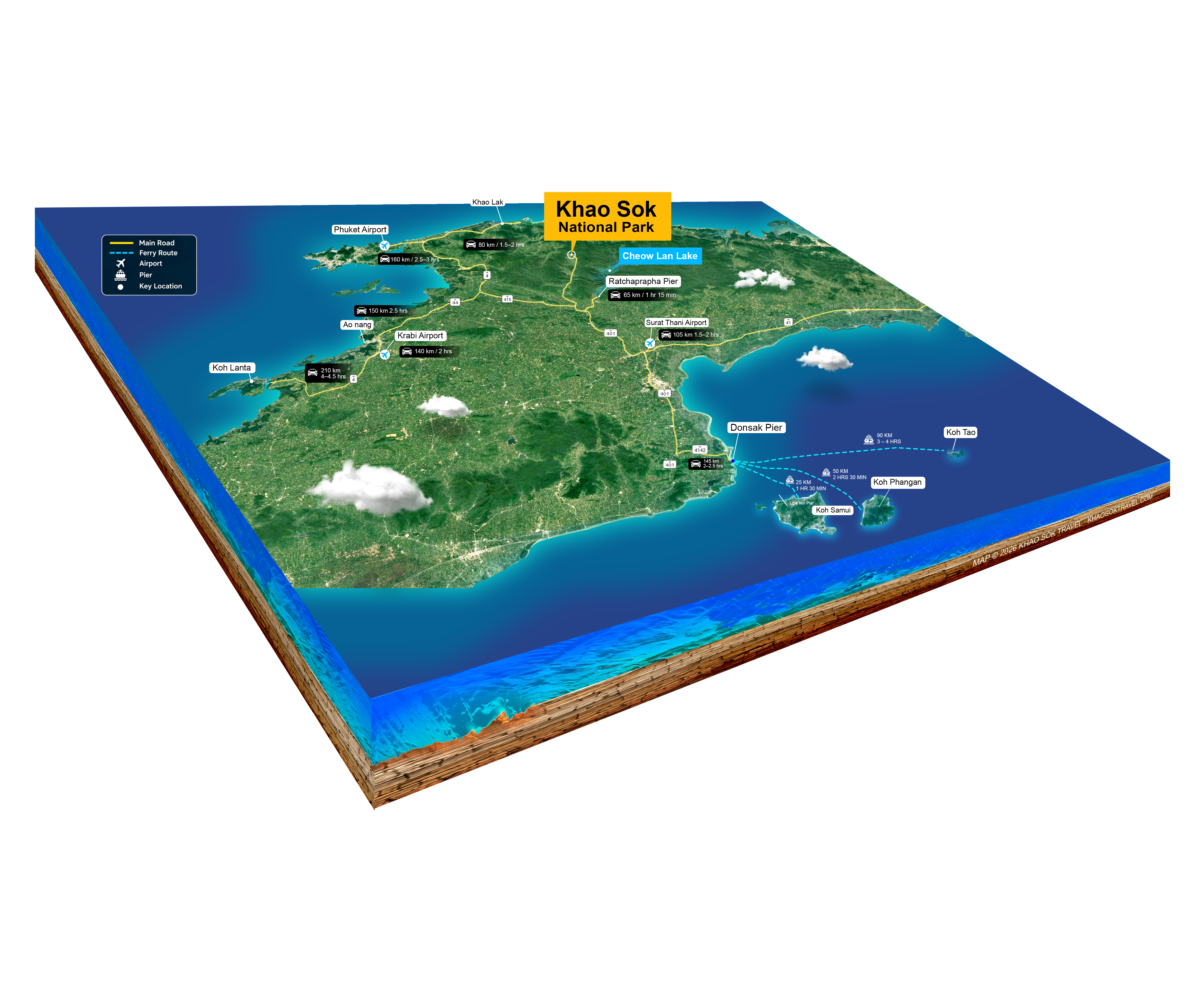
Click the map to enlarge and explore the routes.
EXPLORE KHAO SOK
The Khao Sok Journey Map

From the Rainforest to Cheow Lan Lake

See how Khao Sok Village, the National Park Headquarters, Highway 401, Ratchaprapha Pier and the main attractions of Cheow Lan Lake connect across the region.
Use the map to understand the two gateways, key landmarks and the route between the rainforest and Cheow Lan Lake before planning your trip.
EASTERN SIDE
Cheow Lan Lake & Ratchaprapha Pier
The main gateway to Cheow Lan Lake, where boat journeys depart for floating resorts and attractions across the reservoir.
-
Longtail boat departures
-
Floating resorts
-
Lake attractions
-
Routes deeper into the reservoir
WESTERN SIDE
Khao Sok Village & Park Headquarters
The main base for exploring Khao Sok on land, with the National Park Headquarters, accommodation and restaurants nearby.
-
Jungle trails
-
National Park Headquarters
-
Sok River activities
-
Hotels & village stays

RATCHAPRAPHA PIER
Cheow Lan Lake Gateway
KHAO SOK VILLAGE
Park Headquarters

🧭
IMPORTANT TO KNOW
The two gateways are connected by road, not by a visitor route through the forest. If your itinerary includes both the Khao Sok Village area and Cheow Lan Lake, allow time for a separate road transfer between them.
CHEOW LAN LAKE
Understanding Cheow Lan Lake
Cheow Lan Lake is the reservoir created by Ratchaprapha Dam. Covering approximately 185 square kilometres, its long arms extend between limestone mountains and forested valleys across the eastern side of the Khao Sok landscape.
A reservoir surrounded by a much larger protected landscape.


Forest area:
110,000 rai
Water area:
75,000 rai
RATCHAPRAPHA PIER
Main gateway to the lake
FLOATING RESORTS
Stay overnight on the water
LONGTAIL BOAT
The main way to explore
🌳 THE SURROUNDING LANDSCAPE
The reservoir winds between steep limestone terrain and extensive forest. Much of the landscape around the lake is protected, with Khao Sok National Park adjoining other conservation areas in the wider forest complex.
💧 THE RESERVOIR
Cheow Lan Lake is not a natural lake. It formed after the construction of Ratchaprapha Dam in the 1980s, flooding former valleys and creating the waterways, islands and steep-sided shorelines seen today.
🧭
MAP NOTE
The lake is much larger than it first appears. There is no road network around its shoreline, and destinations across the reservoir are reached by boat from Ratchaprapha Pier. Boat journey times vary considerably depending on the destination.
LAKE ROUTES
How the lake's main attractions connect.
Boat routes are only part of the journey.
Many of Cheow Lan Lake's best-known locations cannot be reached by boat alone. Some involve a jungle trail, a steep climb or a combination of boat, walking and bamboo raft travel. This map helps show how the main routes fit together.

BOAT ROUTE
The main way to move between areas of Cheow Lan Lake. Most journeys begin at Ratchaprapha Pier.
JUNGLE / HIKING TRAIL
Some caves, waterfalls and viewpoints require travel on foot after leaving the boat. Trail difficulty varies considerably.
BAMBOO RAFT
Used on the route to Pakarang Cave, where the journey combines boat travel, walking and a short bamboo-raft crossing.
KHAO SAM KLOE
Where Is Khao Sam Kloe?
Cheow Lan Lake’s famous three limestone pillars.
Khao Sam Kloe is located on Cheow Lan Lake and is reached by longtail boat from Ratchaprapha Pier. The three limestone pillars rise directly from the water and are one of the lake’s best-known landmarks. Most lake tours stop here briefly for photos while travelling deeper into the lake.

Khao Sam Kloe on Cheow Lan Lake — a well-known landmark along the main boat route from Ratchaprapha Pier.
LOCATION
Cheow Lan Lake, Khao Sok National Park
ACCESS
By longtail boat from Ratchaprapha Pier
TYPICAL STOP
A short photo stop on the way to other areas of the lake
PAKARANG CAVE ROUTE
Pakarang Cave: A Journey in Three Parts
Boat, jungle trail and bamboo raft — the map explains how the route actually works.
Pakarang Cave is a good example of why attraction pins alone are not enough to understand Cheow Lan Lake. Reaching the cave involves several different stages, with the route continuing over land and across an inland waterway after leaving the longtail boat.

01 · ARRIVE BY BOAT
The journey begins on Cheow Lan Lake, with longtail-boat travel to the access area for the cave route.
02 · CONTINUE ON FOOT
From the lake, the route continues through the forest on foot. Trail conditions can change with recent rainfall and water levels.
03 · CROSS BY BAMBOO RAFT
A bamboo raft carries visitors across the inland water section before the final approach to Pakarang Cave.
🧭
WHY THIS MAP MATTERS
On a conventional map, Pakarang Cave appears as a single destination. In practice, reaching it is a multi-stage journey. Boat access, walking conditions and the bamboo-raft crossing all need to be considered when planning the visit.
TERRAIN
Kraisorn Viewpoint
Why a short distance on the map can mean a demanding journey.
Many of Cheow Lan Lake's best-known locations cannot be reached by boat alone. Some involve a jungle trail, a steep climb or a combination of boat, walking and bamboo raft travel. This map helps show how the main routes fit together.

READ THE TERRAIN

KRAISORN VIEWPOINT
Elevated limestone ridge


Kraisorn Viewpoint sits above one of the more remote sections of Cheow Lan Lake. Reaching it involves travelling across the reservoir by boat before continuing on foot through steep limestone terrain. The map is a useful reminder that locations which appear close together geographically can require very different amounts of time and effort to reach.
ACCESS
Boat + hiking trail
TERRAIN
Steep limestone trailir
VIEW
Elevated views across the reservoir
🧭
WHY THIS MATTERS
Kraisorn is a good example of why Cheow Lan Lake should not be planned by straight-line distance alone. Boat travel, landing points, trail difficulty and terrain all affect the time required to reach a destination.
WHERE TO STAY ON THE LAKE
Where the Floating Resorts Are Located
On Cheow Lan Lake, where you stay affects how you explore.
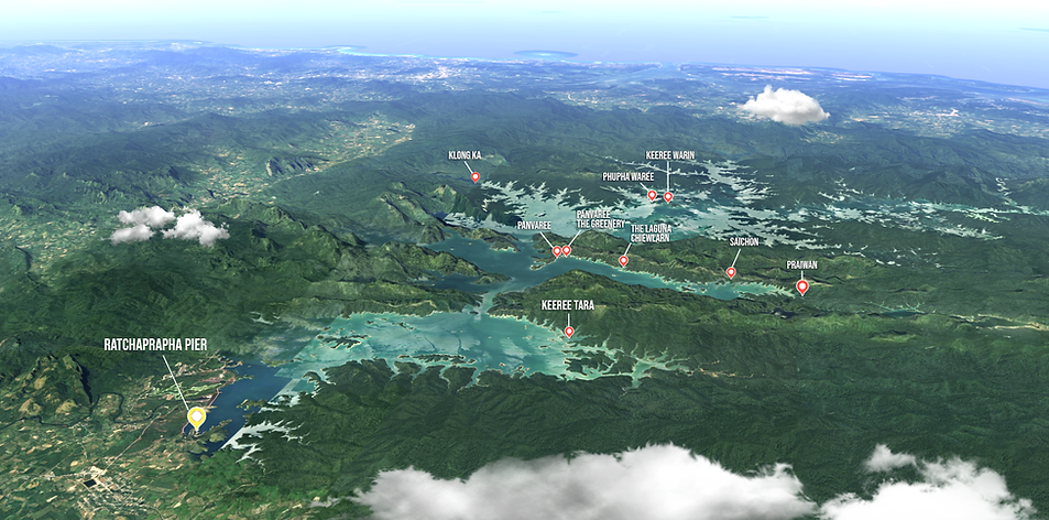
Cheow Lan Lake’s floating resorts are spread across different arms of the reservoir rather than concentrated in one area. Their locations affect boat travel time, access to nearby attractions and how an overnight itinerary can be planned.

BOAT TRAVEL
Floating resorts sit at very different distances from Ratchaprapha Pier. A resort deeper inside the reservoir generally requires a longer boat journey.
NEARBY ROUTES
Attractions are also spread across the lake. Staying closer to a particular area can reduce unnecessary backtracking by boat.
ITINERARY BASE
For overnight trips, the resort is more than accommodation — its location becomes the base from which the surrounding part of the lake is explored.
🧭
PLANNING NOTE
Do not choose a floating resort by room style alone. Location matters. Two resorts with similar accommodation can lead to very different boat routes, travel times and sightseeing possibilities.
FROM MAP DISTANCE TO REAL TRAVEL TIME
Boat times are approximate. Weather, water conditions, boat type and operational routing can affect actual journey times.
PLAN FROM THE MAP
Turn location into a better itinerary.
A good Khao Sok itinerary is not built by choosing attractions first. Start with where you are staying, how you will reach the area and how much travel time sits between each part of the trip.
01 — STAYING IN KHAO SOK VILLAGE
Use the land side as your base.
If you are staying around Khao Sok Village, plan jungle walks, river activities and other land-based experiences from this side of the park. Cheow Lan Lake should be treated as a separate journey rather than something immediately beside the village.
Best map reference:
Western Side / Park Headquarters
02 — GOING TO CHEOW LAN LAKE
Start with the pier.
Ratchaprapha Pier is the main starting point for boat travel onto Cheow Lan Lake. Whether you are visiting for the day or staying overnight, road transport brings you to the pier first and the journey then continues by boat.
Best map reference:
Ratchaprapha Pier → Lake routes
03 — STAYING ON THE LAKE
Your resort location changes the route.
Floating resorts are spread across different parts of the reservoir. A resort closer to the pier may shorten the initial boat transfer, while a resort deeper inside the lake can place you nearer to other areas and attractions.
Look at the resort location together with your planned activities rather than choosing accommodation by room type alone.
Best map reference:
Floating Resort Location Map + Distance Table
04 — COMBINING BOTH SIDES
Build the transfer into the itinerary.
If your trip includes both Khao Sok Village and Cheow Lan Lake, allow for a separate road transfer between the two gateways. The village and the pier are not connected by a road through the national park.
This transfer should be treated as part of the itinerary, not as an afterthought.
Best map reference:
Western Side ↔ Eastern Side
🧭
PLANNING RULE
Plan by access and travel time, not by how close places look on the map. In Khao Sok, the route — road, boat, trail or a combination of them — often matters more than straight-line distance.