top of page
EXPLORE THE LANDSCAPE

Khao Sok & Cheow Lan Lake
3D Atlas

A DIFFERENT PERSPECTIVE

Beyond the Map.
Into the Landscape.

Discover the geography behind every journey.
Khao Sok & Cheow Lan Lake
3D Atlas

Explore the landscapes
of Khao Sok through detailed 3D maps
of Cheow Lan Lake, floating resorts, rainforest, limestone mountains and natural landmarks.

all-rafthouse.png

Cheow Lan Lake Floating Resorts Map

A 3D overview of floating resorts and Ratchaprapha Pier on Cheow Lan Lake.

khao sam klue.jpg

Khao Sam Kler — Three Brothers

A close-up 3D view of the Three Brothers limestone landmark on Cheow Lan Lake.

khaosok area(1).jpg

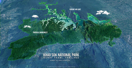
Khao Sok National Park — Forest & Lake Overview

A broad 3D view of Khao Sok National Park, its rainforest and Cheow Lan Lake.

klongsang.jpg

The Journey into Khlong Saeng

An illustrated boat route toward the Khlong Saeng side of Cheow Lan Lake.

kraisorn2.jpg

Kraisorn Viewpoint 3D Map

A 3D perspective of the mountain terrain around Kraisorn Viewpoint.

map5.jpg

Cheow Lan Lake 3D Landscape — Main Lake

A stylized 3D cutaway showing forest and water areas around Cheow Lan Lake.

mpa6.jpg

Forest & Water Area — 3D Terrain Model

An alternate stylized 3D terrain model of forest and lake areas.

pakarang cave.jpg

Pakarang Cave — Trek & Bamboo Raft Route

An illustrated route combining jungle walking and bamboo rafting toward Pakarang Cave.

pakarang pet.jpg

Pra Kai Petch Cave — 3D Location

A 3D landscape view showing the labelled approach to Pra Kai Petch Cave.

Untitled-1.jpg

Khao Sok Rainforest & Cheow Lan Lake Region

A regional 3D diagram showing Khao Sok village, national park headquarters, Highway 401 and Cheow Lan Lake.

bottom of page